We may earn revenue from the products available on this page and participate in affiliate programs. Learn More ›
I’m trying to kick my crampons into the glacier when I feel a tug on my harness. As the middle of a three-person rope team, it’s easy to mess up the cadence: too fast and there will be too much slack in the rope between me and our guide, Alexandra Croft, at the front of the line. But too slow and the rope pulls taut, a physical reminder that if I don’t figure out how to take that next step I’m never getting to the top. I remind myself that Croft isn’t trying to rush anything, so I call up ahead that I need a few seconds to get my footing. After stomping some more, I eventually get enough traction to shift my weight forward. Now I just need to do that a few hundred more times.
Can I Do This?
“As long as you’re in hiking shape, you’re good to go!”
This is what the PR rep for Helly Hansen, Kerri Dellisanti, tells me, when I ask if my lack of mountaineering experience will be an issue on the trip she’s planning: a climb up 8,681-foot Sahale Peak in the North Cascades to test out the brand’s gear. I’m not sure exactly what Dellisanti means by hiking shape, but I can’t think of a time in the last decade where I couldn’t have kicked out at least 10 miles with a loaded pack, so I tell her that I’d love to go.
I’ve hiked and backpacked thousands of miles but have only been to the top of a few peaks. The most impressive of these was 14,505-foot Mount Whitney, the highest peak in the lower 48. But the truth is that it was really more of a day hike detour from the nearby Pacific Crest Trail—what my husband and I were actually hiking at the time.
The scene at the Mount Whitney summit was a zoo. There were dozens of people, essentially high from the lack of oxygen, documenting their achievement in breathless tones using their phones. I hopped up on a pile of granite slabs that I guessed was probably the actual top of the peak, found the elevation marker, and took a snapshot of it. Then I noticed that there was a second marker nearby. I took a snapshot of that one, too. I ended up with photos of four different elevation markers before calling it quits. The oldest one was from 1928.
The exact location of Whitney’s apex was somehow both unimportant and also the literal objective of the climb. For me, that was just as well, since the view from the top was somewhat less spectacular than I’d anticipated. Other nearby peaks seem to stand taller than us and the view of the Great Basin, to the east, looked strangely diminutive and lackluster. The best view was to the west, where we had been hiking the day before. The elevation marker photos ended up being some of my favorites from the summit trek. After that, we didn’t attempt any more summits on either that hike or the Colorado Trail a few years later, even when they were just a few miles away. It was more fun, we thought, to keep hiking toward what those folk at the top were just looking at.
But my general lack of interest in peakbagging was also part why I hadn’t explored a whole lot of the North Cascades. Despites its considerably lower elevation numbers, the ruggedness and remoteness of the terrain makes large swathes of it difficult to access. There, sometimes the only way to go farther is to go straight up.
Three Miles in Three Hours
The stats for our first day look like a cake walk: 2,500 feet over three miles up to a camp in Boston Basin, the launching off point for the main part of our climb the following day. On paper, that just looks like another day in the Cascades, and a pretty short one at that. If you’re going anywhere, you’re probably going up or down about a thousand feet a mile. But that’s on trails, and I’m not totally sure the route up to Boston Basin qualifies. It’s overgrown in some places, rotting away in others, with occasional sections that are so steep that I have to use my hands and arms to pull myself up. Our guides explain that not only does North Cascades National Park not maintain the approach trails for the climbs, they won’t allow anyone else to either. Part of me wants to go faster, but Croft and Sean McNally, the other guide from Mountain Madness, keep a methodical one mile per hour pace that probably saves me from bonking.

It takes the better part of the afternoon to complete the climb, and we don’t arrive at Boston Basin until just a couple of hours before nightfall. Our plan to train for the next day’s ascent is abandoned as we instead focus on getting camp set up before dark. Heather, a freelance gear reviewer on the trip, and I get the provided tent set up quickly without even glancing at the directions; this part, at least, is familiar. Everything that’s left in my pack is less so: ice axe, harness, carabiners, helmet, crampons, glacier glasses. Even my pants, the Helly Hansen Verglas Tur Pant 2.0 (which should be available in spring 2024), are different, reinforced at the knees and inside cuffs and outfitted with Recco, a lightweight, passive transponder that rescuers could use to locate me (or at least my pants) in the event of a disaster. Usually I hike in running shorts.

We spend the rest of the evening having dinner and discussing what we’ll need for the climb, and how best to pack it. The view from basecamp alone is already one of the best vistas I’ve seen in the mountains, especially when the alpenglow hits. Even the view from the open-air bathroom is spectacular: glimpses of faraway peaks nestled between closer mountains, and flanked by endless forest. We can see a half dozen glaciers just from where we’re sitting, including the Quien Sabe glacier, which we’ll be climbing on our way to the summit of Sahale Peak the following day.
Read Next: Best Backpacking Food
Pre-Dawn Start
Our alarms go off at 4 a.m. the next day. After a quick breakfast, we fill up our water and stash our layers: The climb starts steep and only gets more vertical from there, so we’ll warm up fast. Our headlamps are still on when we start picking our way over small trickles, overnight melt streaming down from the glaciers. Soon, we hit a small fork in the trail, and head right up a ridgeline where shrubby huckleberry bushes border the path. We stow our headlamps as auburn leaves colored by morning alpenglow come into focus, a sign that we need to keep moving. The glacier is solid after the cooler overnight temps, but it’s not going to stay that way once the sun hits it.

The trail fades at the edge of a scree field. We all trade another layer for our helmets before following a series of questionable cairns up. It’s not exactly an official route. The cairns have been left by other climbers to indicate reasonably passable sections of the scree field. At least, passable when the cairns were put up; even as we climb, we can see and hear rocks dislodging and careening down as the landscape shifts. Mostly this happens far enough from us that we don’t need to move, but a few times it’s close enough that we instinctively duck. More than once, we’re the ones that dislodge the rocks, which seem to move and shift every time we step on them.

Eventually we hit the edge of the glacier. Earlier in the season, when last winter’s snow was still on the ground, this demarcation might not have been so dramatic. It’s not so much that it’s a wall of ice, even though it’s over five feet off the scree field in places, it’s that it is hollowed out underneath into a series of blue-tinted passageways. The glacier might have looked immutable from camp, a singular slab of ice that’s stood there for hundreds if not thousands of years, but up close it’s anything but static.

I’m used to seeing evidence—like the four elevation markers on Whitney—that the mountains have been shifting and moving over the years. But here the mountain is practically vibrating. Glaciers can move a foot or more a day as gravity slowly pushes the ice, and all the rock and debris trapped inside of it, down and out. With the scree field now behind us, I realize that’s what we’ve been hiking on, part of the mountain that was ground up by the glacier and spit out the other side. The glacier and the scree field below don’t just look different now than they did a decade ago, or last year. They probably look different now than they did yesterday. Under those conditions, it’s surprising that we even had a cairn pile to follow.
Up the Glacier
We take a longer break here, eating snacks and getting out the rest of the gear: climbing harness, carabiners, crampons, and ice axe. Sean talks us through how to take a snapshot, both literal and mental, of the glacier as part of the route-planning process. Right now we have a fairly sweeping view, and he calls out landmarks that will remind us when we need to swing wide to avoid a series of deep crevasses that will block the route. When we’re on the glacier, we might not be able to see some of these traps until we’re walking up to them.
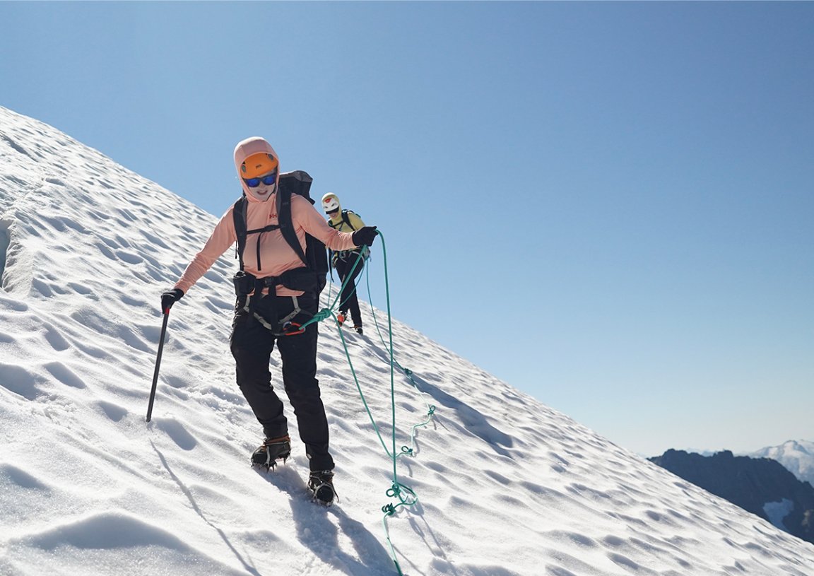
While my climbing partners and I work on figuring out the gear, McNally and Croft tie brake knots in the ropes. Our six-person group will be on two teams on the glacier, each with one of the guides. They’ll keep themselves positioned upslope from us during the climb so that if we slip on the ice and can’t self-arrest fast enough, they’ll be able to catch us.
Gear on and roped up, we hoist ourselves onto the glacier, and start heading up. There are no trails here, or even cairns, to mark our way. There are, however, dozens of crevasses. Some of them are simple wedges; others are deep enough that I can’t see the bottom. I know that because we get surprisingly close, even going in between two at one point on a section of ice that is around ten feet wide.

We’re making good time until we hit the steepest parts of the glacier. The angle here isn’t too far off from the part of the climber’s route the day before when I was grabbing onto roots and branches to pull myself up. But here all you can do is jam as many of your crampons’ spikes into the ice as you can and sidehill. Everything feels heavy, like gravity is slowly pushing us down the mountain along with the glacier. At one point, I look up to check out the view a little too quickly, and the sheer scale of it nearly throws me off balance. I also kick myself in the ankle more than once—but the reinforced sections of the mountaineering pants protect me from the spikes on my feet. Our progress is significantly slower now, but with every step we’re gaining on the summit.

The glacier stops about fifteen feet below the ridge, with an angled rock wall separating us from the top. Climbing the rock face is pretty fun, even if it’s out of my area of expertise, except for the part where we’re still wearing mountaineering boots and crampons. The sound of my spikes scratching against the rock as I pull myself up is a reminder of just how little grip I have, but a few minutes later, I top out on the saddle.
The Final Push

The vista on the other side is just as breathtaking and expansive as it was from Boston Basin, maybe more so. There is a new glacier below us, the Davenport Glacier, with streams of water flowing down into Horseshoe Basin. On the opposite ridge from us is a large glacial lake in deep blue, perched high up on a ridgeline. Where our view from Boston Basin had only fleeting glimpses of faraway peaks, here we can see them stretching out to the horizon line.
Read Next: Best Trekking Poles
This is where Sean tells us that we could call it quits if we want. It’s not that much farther to the summit of Sahale Peak, and getting up the glacier is an achievement on its own. We start asking how much higher the summit is, how difficult the climbing—it goes on for long enough that eventually Sean tells us that he’s making an executive decision: We’re all going to the top. It is close by, but it somehow also looks even more unlikely a thing to climb than it did when we were back at camp.

The first part is easy enough, a careful stroll along a knife’s edge, just wide and flat enough for there to be plenty of secure foot placements—a nice change of pace after the glacier. But after we’re down the ridge, it turns into some true rock climbing. First there is a slab of sheer rock to scale up, bisected by a couple of inches of ledge, with only a few spots to jam your fingers into, to get to the base of the chimney. From there, we’re pulling ourselves up using a large crack in the center of rock along with a few generous handholds. I’m not at all convinced that “hiking shape” was what I needed to be in to tackle this section, but eventually, with some coaching on how to leverage my body up a few sections, I get there and top out.
The view is better up here—truly—so I’m glad we made the climb for more than just its own sake. There are even more peaks extending out to the horizon line, and the effect of being on top of such a skinny summit is that the 360-degree views extend not just out, but also below. Sean jokingly asks if anyone took a picture of the elevation marker. (Someone had, of course.)

I stare out at the view for a while until the line of the ridge on the opposite side draws my attention down. There are a few crescent moon shapes built out of slabs of rock: campsites. Turns out there is another route to the top of Sahale Peak extending down on the other side. I can see a trail winding down Sahale Arm and disappearing into the woods below the alpine. A route that would allow you to trek even farther on into parts of the mountain that you can only glimpse from the summit.