I pulled up to an obscure two-track on the side of a dirt road years ago while turkey hunting in Wyoming’s Black Hills. A tangled barbed wire fence stretched across the road with a sign saying, “POSTED No Trespassing.”
There should have been a sliver of public land I could shimmy through, attached to a bigger stretch of public, but my paper map was characteristically vague. I fired up a handheld GPS with a chip made by a relatively new company called onX, and it confirmed what I thought I knew: That barbed wire fence and sign were closer to the road than they should have been. Someone was snagging just a little extra property for themselves and cutting off access to a big chunk of public land in the process.
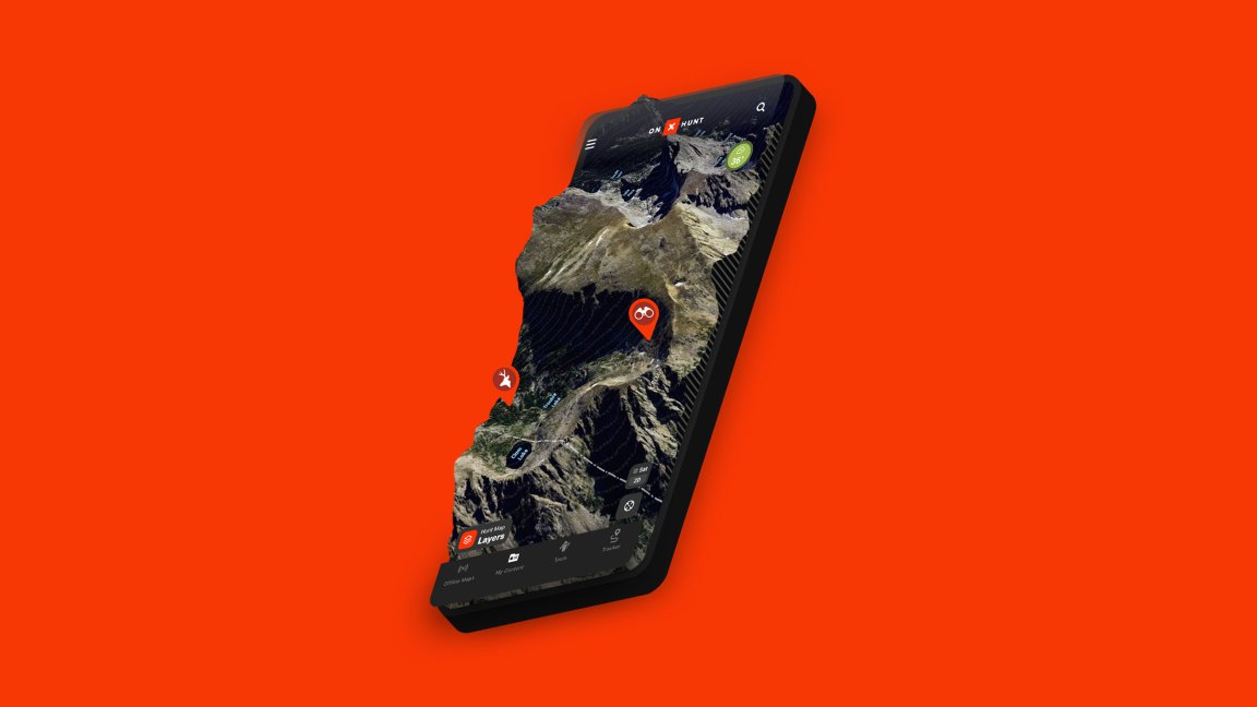
Most hunters and anglers have similar stories about digital maps uncovering access. Few technologies have revolutionized hunting, fishing, and outdoor recreation access more than the ability to see precisely where we are in relation to land ownership boundaries in real time. Now digital maps also allow us to identify burn areas or habitat treatments, view draw odds, and even connect to cellular trail cameras.
But the GPS revolution has had growing pains. Some onX users wonder where all that data is stored, if we’re being tracked in the most remote spaces in the country, and if our waypoints could one day be sold. Biologists worry that more access puts more people in the last spaces where wildlife seek refuge from us, and hunters and anglers complain that novices can now find the same secret spots that they had worked for years to unlock.
“With change comes some people who are winners and some people who are losers,” says Randy Newberg, the Montana hunting advocate and TV personality who has been sponsored by both onX and GoHunt. “They can say, ‘some people know about this, now they know my spot.’ Well, the net of it all is that we as a community are winners based on the premise of having these maps on our phones.”
As mapping companies become more sophisticated, hunters, hikers, biologists, and nonprofits weigh in on the pros, cons, and future of the onX effect.
onX Origins
Like most innovators, Eric Siegfried founded onX because he needed something. He had moved to Missoula, Montana, in 2007, only months after Apple released its first smartphone.
In those days he waited in lines at U.S. Forest Service and Bureau of Land Management offices to collect big paper maps. Then he’d try to parse what he saw on the maps with what he found in the woods.
“You had Garmin GPS information but not landowner information,” he says. “I wanted it on my GPS.”
So in 2009, he used his computer software skills to build a chip that would fit into a user’s handheld GPS device that not only showed where the person was, but who owned the land in and around that spot.
Eventually, onX evolved from a chip to an app and it’s now a multi-million-dollar operation with about 400 employees, three separate programs (onX Hunt, onX Offroad, and onX Backcountry), and millions of users (the private company won’t disclose exact user numbers).
In October, the company announced $87.4 million in Series B funding, a wonky term for a second round of investments. The investment comes from Summit Partners, a firm that has invested in a wide variety of technology companies around the world. It’s the same investment group that provided onX’s first round of money in 2018.
Although onX is still the biggest player in the outdoor GPS game, it’s far from the only one. Companies like GoHunt, HuntWise, BaseMap, HuntStand, GAIA GPS, and Spartan Forge help users plan hunts (as well as hikes, fishing trips, backpacking treks, and anything else they want to do outside, depending on the app), as they try to distinguish themselves from onX and each other.
Like smart phones themselves, these apps have become such integral parts of our lives that even users with big questions about the security of the apps and the effects of their use are reluctant to give them up.
Who Sees Where You Hunt?

Here’s what onX wants to make really clear right now: The company isn’t monitoring your location in real time. When you have tracking turned on, however, your GPS coordinates are being saved on onX servers.
The company gets asked about this a lot.
Land Tawney understands why. The Montana hunter and former CEO of Backcountry Hunters and Anglers uses onX as much as the next hunter. He sits with it at home looking at new spots, downloads maps so he can use them when he’s in the woods and without service, and fires up the app anytime he’s in new country.
Then last fall, he found a piece of tribal land newly opened to the public near an area he’d been hunting for 20 years. He went to mark it in onX so he’d remember where it was for next time, but then… he didn’t.
“On some level, I just didn’t want other people to know about it, and maybe that’s even someone grabbing my phone while we’re looking at onX,” he says. “I found it because of the app, and anyone else could find it. But still.”
In some ways these privacy concerns are unwarranted — after all, how valuable is a single user’s data when every onX user gets to see the same maps in the first place? In other ways, however, privacy concerns around digital apps use are totally warranted. That’s because the data points — just like the contents of your Gmail, TikTok, Instagram and Facebook — aren’t completely private.
Companies are not legally bound by the Constitution’s Fourth Amendment to keep information you share with them a secret, says Ryan Semerad, an attorney with the Fuller & Semerad Law Firm in Casper, Wyoming, who was recently involved in the controversial corner-crossing case. By signing up with onX or other GPS location services, Gmail, and many social media sites, you’re implicitly giving those companies permission to look at your private information.
One consequence here is that those data points (or waypoints) can be handed over to law enforcement and then, if part of a trial, become public.
Four Missouri hunters represented by Semerad got to learn just how that process works. They became famous in 2021 after using onX to pinpoint the exact spot where two corners of public land touched on a sagebrush-covered hillside in southeast Wyoming. They used a ladder to cross from one public square to another, killed elk and deer, and used the same ladder to pack out the meat.
Three years, one trespass trial (where the hunters were found not guilty), one civil trial against the hunters (which a judge dismissed), and even more appeals later, the case has become the poster child for what GPS mapping can achieve. But after the courts forced onX to produce evidence of where the men had walked, attorneys spent weeks bickering over a point one hunter made on his onX that was later named “Waypoint 6.”
The landowner’s attorney said Waypoint 6, a spot marked on private land, proved the hunters had, indeed, trespassed. The hunters’ attorney said the point proved only that the hunter pressed a spot on a map with his finger — evidence of how we all fat-finger our phones — not proof of criminality.
The hunter himself, Zach Smith, told Outdoor Life recently that he has no idea how the point got on his onX, only that he may have created it while using the phone with gloves on, or in the snow or rain, and erroneously hit a location, not because he was actually in that spot.
Regardless, the incident shined a bright spotlight on the fact that the data we store in onX is not truly private.
While onX officials acknowledge they do have to comply with court-ordered subpoenas, they say the only other way they give out information to anyone other than the individual user is through missing persons cases. In these situations, the location data could help in a rescue or recovery, says Zach Sandau, onX’s hunt marketing manager.
Semerad, the attorney, doesn’t use onX because he doesn’t hunt or fish. But he considers onX and its feared risks to be similar to the rest of the technology we carry around.
“It’s a modern cost-benefit analysis. It’s so freaking useful. Are we really going to give up the usefulness for the concern?” Semerad says. “I think it’s been shown time and time again, no matter how many times lawyers and leaders and politicians talk about how unsecure Facebook, Instagram, and onX are, people don’t care. We know they’re harvesting our information, and we’re not stopping using it.”
But could all the data we’re putting down in onX be aggregated and sold? Say, for example, an aggregation of all the turkey “roost tree” waypoints on public lands. Could onX compile that data, display it as a turkey roost heat map and then sell it to users who are willing to pay a much higher premium?
onX says no.
“We consider user markups (like waypoints) to be personal content, and thus owned by each customer,” the company’s senior communications manager Molly Stoecklein wrote in an email after checking with onX’s legal team. “Our license to use that personal content is limited to activities ‘in connection with the Service’ (for example, analyzing how customers use our app to improve the app with a more intuitive experience).”
But could they batch that information and sell it anonymously to advertisers, by considering advertisers “in connection with the Service?” Again, onX says no.
The company’s answers are all based on their user agreements, the ones we all sign to create an account. Could those agreements change? Sure, Semerad says, but not without asking us to sign another legal agreement, which most of us won’t read anyway.
He also notes that he’s less concerned with a company like onX selling data and working around the shady fringes of privacy because, unlike a free site like Facebook, Gmail, or TikTok, onX is beholden to its subscribers.
“onX needs to make subscribers happy,” Semerad says. “Facebook needs to make advertisers happy. In the free social media world, we’re grist for the mill.”
Does Better Access Mean More Pressure?
For most of the past century or so, reigning public opinion said more people outside meant more awareness of outdoor issues, which meant more advocates for the outdoors.
The idea wasn’t unfounded, and most conservation and environmental nonprofits champion getting people outside and experiencing nature. Not only is it good — critical even — for our own health and well-being, but as Tawney says: “The only way that people will care in 100 years from now is because they got out there and touched and felt it.”
However a growing body of research shows our presence in the backcountry, where wildlife is pinched into even tighter spaces, is taking its toll. Skiers push a bighorn sheep herd in Wyoming’s Tetons to the brink; runners, hikers, and bikers likely caused a crash in elk numbers near Vail, Colorado; lookie-loos in Montana and Wyoming bump grizzly bears off moth sites.
And digital maps make it all that much easier for more people to go farther and deeper than ever before.
“I think there still would have been more people in the woods, but they wouldn’t have known everywhere to go,” says Bill Andree, a retired biologist who studied the Vail elk herd during his time with Colorado Parks and Wildlife. “But is it 2 percent or 20 percent? I have no data.”
Add in social media and the issue becomes worse. Now a barely-used trail that’s easy to find on a digital map, leading to a little-used spot in the woods may be shared far and wide on the internet, says Aly Courtemanch, a Wyoming Game and Fish biologist in the Jackson region.
“It is enabling people to discover new places they want to go,” she says, “but also these areas that may have had virtually no human presence will [now] become popular.”
Is that an inherently bad thing? No, she says, but we do need to be more aware of our impact on wildlife.
For Siegfried, the founder of onX, the problem isn’t digital maps, it’s a management issue. If agencies feel that too many people in one spot are taking a toll on wildlife, then those agencies should create restrictions to alleviate the pressure.
And companies can help build awareness for those rules, adds Stoecklein. For example, onX now includes bighorn sheep layers in the Tetons so skiers know exactly which areas are off limits.
Is the “Secret Spot” Dead?
Spend a little time scrolling online forums, and you’ll think mapping apps are ruining hunting nationwide by breeding lazy hunters who don’t need to put in the same legwork as their fathers or grandfathers.
Instead of calling fish and wildlife management agencies in each region in each state, and talking with forest service rangers, and tracking wildfires, and keeping in touch with county clerks, all that information is updated regularly on an app on your phone. Even many state agencies are sending land ownership changes and other critical hunt information periodically to companies like onX.
But handheld GPS mapping hasn’t made hunters lazy, Newberg says. It’s just flattened the learning curve.
“I know every range con at the BLM and forestry guy at the Forest Service and built relationships with them before the digital map. Was that fair? The people who say it isn’t fair are the ones who had the inside track before,” he says.
Newberg and Tawney both see mapping apps as equalizers — as ways to help more people get outside and hunt. GoHunt’s tag information particularly rankles people who used to know that, say, a certain Nevada mule deer hunt area never had many applicants and as a result they could draw a tag more often.
But even before the apps, companies were compiling that information for a fee. The apps just make it easier to find and available to those with smaller bank accounts.
Newberg says that the real reason for the drop in application success is that there are generally fewer animals on the landscape.
“When I started doing this, Wyoming had about 650,000 pronghorn, now it’s bordering around 300,000. I’m a CPA and pretty good with numbers, and I know when you have 650,000 animals, the number of tags will be way better than when you have 300,000,” he says. “That’s hard work to turn around. That’s conservation and habitat. We need to build a bigger pie.”
Have the half-dozen or so GPS mapping companies cut down the chance for someone to have a public-land secret spot? Maybe, Newberg says, but public-land secret spots are an oxymoron to begin with. They come and go over the years. And if nothing else, he figures mapping apps have opened even more possible honey holes by revealing with pinpoint precision those places we can shimmy through and around.
Read Next: 7 Sneaky Ways Landowners Block Access to Public Lands
“People will say I view [mapping apps] as a positive because I am sponsored by them,” he says, referring to his current partnership with GoHunt. “But when I am too old and crusty to be sponsored the way I am, I will still use digital maps.”
onX says it plans to continue partnering with nonprofits like Pheasants Forever and the Rocky Mountain Elk Foundation to open landlocked public land to hunting, particularly in the West where about 16.43 million acres of public land across 22 states remains inaccessible. In December, the company announced it had provided grants that “improved access” to more than 150,000 acres and built or restored 255 miles of trails.
Maps for the Masses
Here’s one thing we know for certain: Digital mapping apps aren’t going away. More companies mean more competition, which creates even quicker evolution. And each app is working to set itself apart with more comprehensive, detailed data.
onX will almost certainly use its recent investment to continue expanding beyond the hunting world. The company’s current CEO, Laura Orvidas, would not dive into details about what’s next for onX, but she did write in an email to Outdoor Life that: “We’re looking to inspire new types of recreation with a new product later this year.”
Despite data privacy concerns, users will keep subscribing simply because we have to. After using onX, there is no going back. As a prime example, even after all the charges and legal trials, those four Missouri hunters who corner crossed in Wyoming still use onX — and still love it.
“I believe the onX technology is one of the greatest tools for the outdoor community. We most likely could not have done what we did without it,” writes Missouri hunter Brad Cape in an email to Outdoor Life. “I’m not concerned with the information they store. Almost every organization out there is storing personal information.”