The history of America’s West is marred by disputes over land ownership—if not all-out wars—and so too will be its future. During the COVID-19 pandemic, well-off residents from California, Washington, and Texas sought their own slice of the mountains and moved to Montana in droves. For every 100 people that left the state in 2020, 372 moved in. As a result, many mountain town locals have felt a crowding and degradation of their public lands and waters.
In Montana, the state stream access law remains a bright spot. But public water hunters and anglers have found themselves increasingly at an impasse with the new, fast-growing population of riverfront landowners, thanks to the mass-wealth migration that’s priced many multi-generation Westerners out of their hometowns. Cookie-cutter housing developments full of large, sleek abodes sprawl across valley floors in places like Gallatin County, eating up what was traditionally agricultural land nestled between vast mountain ranges. In March 2023, the median cost of a single-family home in Montana’s wealthiest county was almost $700,000. (Thirteen months before that, it was $1.1 million.)
What follows is the story of how one small bit of river access on the outskirts of Bozeman disappeared after years of complaints and dispute between the public and new landowners from California. The impact of the closure is small; anyone with a map can find other access points to the Gallatin River just a few miles upstream and downstream, assuming the parking lots aren’t full. But this story’s main characters say this is a cautionary tale for what the West could look like in the future. In other words: As more wealthy out-of-towners move in, locals will lose public access not through some dramatic showdown, but through slow, mind-numbing, bureaucratic processes.
Access Lost
Matt Treinen was searching the sky for mallards when his phone buzzed in his pocket. A restricted number made him wary of answering, but he picked up on impulse. It was a Gallatin County sheriff’s deputy, telling Treinen he needed to come back to the access point he used that morning.
Treinen and his hunting buddy Jeremy Sarren left their guns and gear and waded a mile down Montana’s Gallatin River. They took care to stay well below the high-water mark that divides private land from the public water. When the two hunters reached the access point—a worn path climbing the riverbank to a wide shoulder on a county road—they found two deputies parked in a patrol car.
Treinen and Sarren showed the cops the exact route they had used to access the Gallatin River, how they navigated around new fences and “No Trespassing” signs that someone had installed on the shoulder of River Road. Deeming their route to the river legal, the deputies released the two hunters.

But just 15 minutes later, as they were working their way back to their setup, Treinen got another call. The deputy told the hunters to come back.
The landowners who had recently purchased the property adjacent to the road and the river wanted to see trespassing tickets written, Treinen recalls the deputies explaining. These landowners were the same people who built the new fences and posted the access route. Even though the hunters felt certain they hadn’t trespassed, they offered to go back upriver, collect their decoys, and leave—to “let bygones be bygones,” as Treinen puts it.
But the deputies told Treinen and Sarren they’d offered that same solution to the landowners, and the landowners weren’t satisfied. So after the two hunters and two deputies spent 45 minutes searching the Internet on their phones for clarity on Montana’s stream access laws, the deputies gave up and wrote Treinen and Sarren trespassing citations.
Hell or High Water
In Montana, anyone can legally wade a river that cuts through private property under one condition: They cannot step above the high-water mark.
According to Montana law, the ordinary high-water mark is defined as:
“…the line that water impresses on land by covering it for sufficient periods to cause physical characteristics that distinguish the area below the line from the area above it. Characteristics of the area below the line include, when appropriate, but are not limited to deprivation of the soil of substantially all terrestrial vegetation and destruction of its agricultural vegetative value.”
As confusing as those few sentences are to the average person, a lot rides on that water line. It demarcates the liberal freedoms that hunters and anglers have in Montana. But interpreting the exact location of a river’s high-water mark isn’t always easy. Plants grow and die, rocks tumble and settle, and erosion wears away at the bank.
“Much depends on the facts of the situation. Sometimes it’s quite obvious where the high-water mark goes on a particular stream. But in other places, it’s just not that clear-cut, particularly where banks are steep,” Montana attorney and stream access expert Jim Goetz tells Outdoor Life. “That’s a difficult concept sometimes … [but] if the high-water mark moves, it moves, and the new place is the high-water mark, in my opinion.”
The New Neighbors
That morning Treinen and Sarren were ticketed (Oct. 31, 2021) wasn’t the first time Marc and Aurora Cohodes had called the sheriff to over folks accessing the river near their home. It wouldn’t be the last, either.
Marc Cohodes has long been known as the “highest-profile short seller on Wall Street.” He made $40,000 on the stock market by the time he was 16. He and Aurora, who are reportedly now divorced, own a farm and equestrian facility in northern California where Aurora manages a performance horse training operation. They bought the 84-acre property on River Road—just across from Treinen and Sarren’s favorite river access—in September 2020 from a multigenerational Montana ranching family that had coexisted with public hunters, anglers, and other recreationists for decades. The property was listed at $3.8 million at the time, and is currently valued at over $4.7 million. (Aurora confirmed she is no longer on the title to the property but would not comment further on the situation, and Marc’s lawyer did not return requests for comment either.)
The Cohodes property boundary spanned both River Road and the Gallatin River and included a few acres across the river. Gallatin County has owned an easement on River Road since 1892, creating a 60-foot-wide public strip on the property where anyone can walk, drive, or park. Similarly, everything below the high-water mark of the Gallatin River—water, riverbed, and bank—is public property. In places where the county road easement overlaps the Gallatin’s high-water mark, the public can legally leave the road and walk down the bank without setting foot on private dirt.
Locals have accessed the Gallatin River along this road for decades, and Treinen says that it has turned into a popular place. He’s seen construction workers eating lunch out there during weekdays, and friends getting together to drink beer and fish after work.
The Cohodeses and neighboring landowners tell different stories, according to emails, reports, and correspondences obtained through Freedom of Information Act requests. Their experiences include alleged package theft, strangers ambling into their front yard, drug use, human defecation, garbage, and intimidation tactics. So the Cohodeses tried stopping the problem at the source. They hung “No Trespassing” signs near the traditional access points shortly after moving in. When the signs didn’t work, they built fences. But the public access users, who genuinely believed they were allowed to access the river there, couldn’t figure out if the Cohodeses were serious about enforcement or just trying to deter troublemakers.
Many locals continued using the access point, walking around the fences and even ripping them out of the ground. “No Trespassing” signs started disappearing from their posts. Meanwhile, the Cohodeses asked the county to close the road shoulder to public parking “to discourage trespassing and to break up the long standing habits of many local drug users and dealers,” according to a July 2021 letter to the Gallatin County commissioners Outdoor Life obtained from the Treinens. The county did not close the shoulder.
Two months later, Aurora emailed various county officials again—this time about “moving the road easement [farther] away from the bank … allowing clear and obvious land between the easement and the bank for legitimate fencing along the entire stretch.” She explained how “it would provide us a clear path to eliminate trespassing and … would deter much of the activity we are hoping to eliminate.” The county didn’t move the easement, either.
Later in that same email, Aurora addressed Gallatin County Sheriff Dan Springer personally.
“Sheriff Springer, we look forward to more visits from law enforcement and any help you can provide in creating a presence in our neighborhood. We would be happy to take an unused marked car and park it in our yard at any time. It will help us a great deal if we can keep the hostility down and our fences up [smiley emoji].”
That same month, three surveying firms mapped the Cohodeses’ land boundary, the high-water mark of the river, and the county road easement. The resulting map illustrated what onX and Gallatin County’s interactive maps couldn’t: that the road easement and the high-water mark did overlap and create public access in some places along the Cohodes property and didn’t in others. Except the spots where access did exist, which were overgrown with dense brush and trees or too steep to climb down, were not the spots the public had been using for decades.

But this map wasn’t exactly made available to the recreating masses. It was buried in an application for a fence-building permit that the Cohodeses filed with the Gallatin Conservation District. (Their application was denied; they didn’t need the permit because their fences were deemed legal, GCD tells Outdoor Life.) So while the public continued to believe that the old, worn path on the riverbank was a point of public access, the Cohodeses got the green light to complete the fencing project.
The Cohodeses called the sheriff’s department at least 13 times in two years to report trespassing, suspicious activity, harassment, and drug use. They also approached public users multiple times on their own, informing them they were trespassing. They even filed a restraining order against an older man who liked to park along River Road in the morning and watch the sunrise over the river, according to complaints both the man and his son filed with the Gallatin County Road and Bridge Department.
River users filed seven other complaints over 16 months with the same department. They berated the “rich Californians” who were blocking their river access, specifically the “lady in a black car” who “was extremely rude.”
But the Cohodeses weren’t deterred.
“We are on our third attempt at fencing our property,” Aurora wrote on Oct. 21, 2022 to Montana Fish, Wildlife & Parks, as well as the Gallatin County sheriff’s department, conservation district, road and bridge department, and commissioner Zach Brown. “We are in good faith attempting to reduce trespassing, which in turn [sic] reduces traffic, which in turn reduces nefarious activities as the druggies prefer to mix into a crowd.”
The Way Things Used to Be
The Cohodeses bought the 84 acres on River Road from the Leadbetter family a few months after Dan Leadbetter died in February 2020. Dan’s son, Joel, was reluctant to discuss his parents’ ownership of the property because the Cohodeses sued him and other family members, along with the real estate agency named as the broker on the property listing, according to public records from the Gallatin District Court. (Neither Joel Leadbetter nor the Cohodeses would comment on the reason for the lawsuit.) But Joel did note that his parents had a track record of creating public access. On a previous property, the Leadbetters either donated or sold (Joel can’t remember) part of their Madison River frontage to MFWP to create a public fishing access near the town of Ennis. On River Road, the locals got used to the Leadbetters’ pro-access attitude. But after his dad’s death, even Joel complained to the county about the “mess” going on at the access point, according to county records.
Changing the status quo has proven difficult for the Cohodeses. Their efforts have seemingly deterred some users from accessing the river, but others carry on without batting an eye.
“I was told by a kindly but stubborn swimmer last week that he won’t tear down my fencing but he will climb over and under it,” Aurora wrote MFWP fisheries biologist Mike Duncan on Aug. 29, 2022. “Not much I can do about that and I try not to get too excited about these kinds of visitors. Still, I must do what I can to deter trespassing, preserve our bank, and disrupt the drug activities and hostility along our road.”
Gray Areas
Sherri Renck, another local who has fished and ridden her horses up and down the Gallatin River from the River Road access for 20 years, insists that the county and state are wrong in their assessment of where the high-water mark of the river is. She has a background in natural resources, and she filed two complaints with GCD after coming across the signs and fences.
“At the time, I saw the fence starting to go in,” Renck tells Outdoor Life. “It was clearly intimidating, and it appeared that it was going to be a big problem for public access there.”

Renck claimed that the fences were built below the high-water mark of the river, violating state law. This runs contrary to what MFWP reported upon investigating Renck’s complaints, that “the fence is fine and is nowhere near the high water mark” and that “the new sections have smooth cable that are relatively loose and allow for reasonable access,” GCD tells Outdoor Life in an email. But Renck says that anyone familiar with Montana stream access would take one look at the fences and disagree.
“I just shake my head,” Renck says. “This is black and white. Where they have put a fence in that stream bank and bed, they are violating the law. There is no gray area there.”
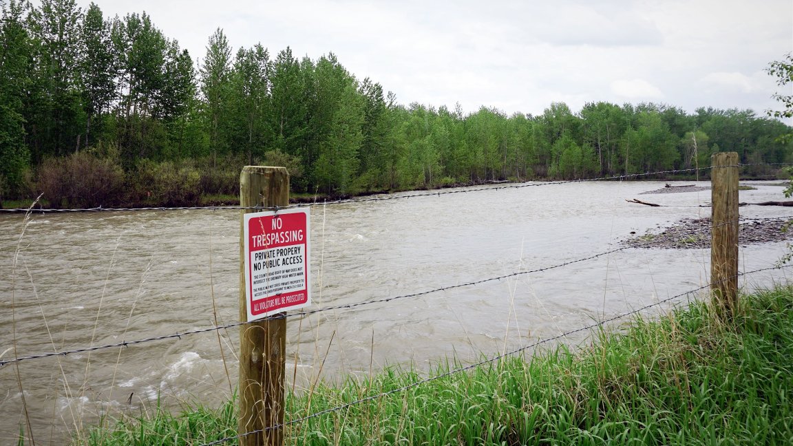
The Future of River Road
This May, the Gallatin River was swollen with spring thaw. It roared next to the dirt road, drowning out the noises of the few vehicles that drove by. Maybe the day’s heavy rain was keeping people away, or maybe people just don’t come around much anymore.
The Cohodes’ property has since been split among multiple new landowners. (The new landowner who controls the contested access point is a real estate development company.) This change in ownership was not reflected on Montana’s cadastral map or popular digital mapping app onX at the time of publication. With new owners, there’s hope that the dispute will dissolve over time.
Despite the years of contention and pushback from the public, from the surface, it looks like the Cohodeses never did anything illegal. According to the survey map from 2021, they built their fences on slivers of private land. Where that map says public access existed, there was no fence. There was no safe, reasonable way down to the water, either; especially not while it churned the color of melted chocolate. But despite its strength and volume, the water wasn’t touching the fence posts. In fact, it wasn’t even close. This winter was a snowy one and melt happened fast, thanks to abnormally high springtime temperatures. This was the highest the water would likely get this year.
But under the eye of the law, the duck hunters didn’t do anything wrong either. Treinen and Sarren didn’t end up getting convicted of trespassing. Their tickets were thrown out in court a few months after the incident. Treinen spent $3,000 on lawyer fees, which he says he’d like to get back somehow to donate to a stream or land access organization.

“If you can’t access [streams] from county roads, it’s going to really restrict the places where people can fish, hunt, and congregate,” he says. “This is a slippery slope in Montana. If we don’t do something here where we do have some rights, people with big money are going to change our laws.”
Read Next: 7 Sneaky Ways Landowners Block Access to Public Lands
He’s not wrong. Elsewhere in Montana, wealthy landowners push for land swap deals that give them exclusive access to public, elk-rich lowlands in exchange for nearly unreachable high country. MFWP holds that, at least in Montana, corner crossing is still unlawful. Here on River Road, the contention may cool with time, but future access is still unclear.
“I remember going in there with my husband after a family member had died,” Renck says. “We rode up the river and fished. To have what we had taken away, it’s just heartbreaking.”
Editor’s note: This story has been updated to reflect that new owners now hold the property that was under dispute. Marc and Aurora Cohodes no longer own the contested stretch of land along River Road.