We may earn revenue from the products available on this page and participate in affiliate programs. Learn More ›
In a few short years, smartphones have completely revolutionized the hunting world. By marrying GPS technology to a high-definition screen, hunters now have a high-tech navigation system no bigger than the size of their hand. In addition, hunters now can download a wide variety of apps designed to enrich the entire experience.
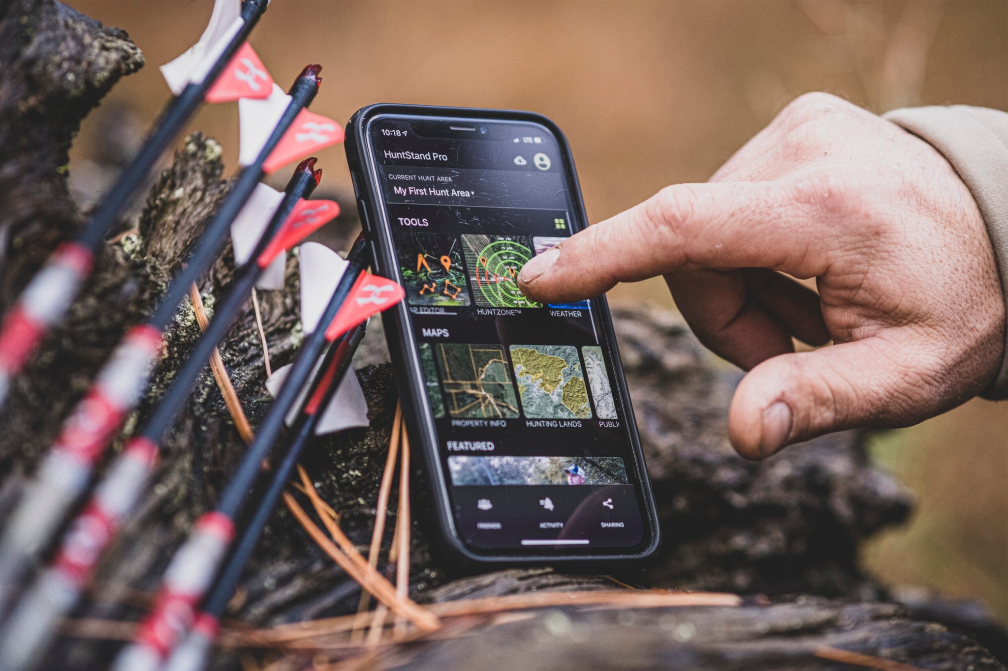
One of the leaders in this field is HuntStand, a South Carolina-based company. In 2013, its designers created a land-tract mapping application that allowed users to build detailed maps of their hunting areas on their smartphones. Hunters could now log game sightings as well as feeding and bedding areas. The free app also allowed hunters to create a network of hunting buddies. As a result, HuntStand quickly became the country’s number one hunting and land management app.
Now the company is offering an upgrade—HuntStand Pro—that makes the app even more valuable to its users. For only $29.99 per year, users can take advantage of the most cost-effective hunting app on the market. The upgrade includes a wide range of advanced features, all designed to improve your hunting efficiency.
To start, HuntStand Pro has just added monthly satellite updates. It’s now the first, and only, app that offers this feature. Truth is, most satellite images used by hunters don’t really display current conditions. In fact, the information on your screen may be years old. But by leveraging micro-satellite technology, HuntStand Pro can offer you nearly up-to-the-minute reads on the conditions of your food plot or deer stand. For instance, if a landowner adjacent to your lease starts clear-cutting timber on his property, which can greatly affect the quality of your deer hunting, you’ll see it on the app, giving you time to move your stand to a more productive location.
If you’ve ever been busted by a big buck that scented you, HuntStand Pro can help make sure that won’t happen again. The HuntZone feature is a patent-pending technology that allows you to see the impact of your scent over time. It shows wind speed, direction, and time in one simple, unified package.
The LandZone feature follows the same concept, but is used for waterfowl hunting to determine where waterfowl will most likely land. With this tool you can plan a waterfowl set-up based on the wind speed and direction, which lets you quickly and accurately set up your decoy spread, in the dark, for best results.
Trail cams are a popular tool for many hunters. HuntStand Pro enhances this experience with several exclusive features. You can upload images into the HuntStand Pro ecosystem so that you can organize them by camera location. These images will automatically sync with weather and Solunar information. You can also tag and view specific game so that you can organize them by camera location. Here, a proprietary range of filter variables, including time of sighting, date, animal type, weather, wind speed, and temperature, lets you discern an animal’s travel patterns, which helps you figure out the best spot for a stand or ground blind. Another exclusive feature is the ability to utilize a Heat Map that allows you to view trail camera activity by location.
Managing stand reservations on shared property can be a cumbersome, time-consuming process. But the HuntStand Pro stand reservation feature greatly simplifies this task. You can search for available stands/blinds in a hunt area by date and time and see what stands are occupied currently—and by whom. You also can see upcoming reservations for specific stands or all stands in a group hunt area.
Another valuable feature is Distance Measurement. This is a tool that can measure the distance between any two points or a series of points in feet, yards, or meters. This allows the user to determine the length of a shot (eliminating the need to bring along a rangefinder) or see how far a stand is from another hunter or from a major food source. Experienced big-game guides know the ability to judge distance accurately often means the difference between punching a tag or going home empty. As a result, you have a tool that takes the guesswork out of estimating distance.
The Area Measurement tool helps you accurately measure the area of a field or clear cut, no matter how irregular its shape, in order to determine just how much seed or fertilizer will be needed for a food plot. Anyone who has ever halted seeding a food plot to run back to the feed store to buy more seed can see the value of this feature.
Offline Mapping capability lets you save your hunt area to the phone for uninterrupted use, even without cellphone coverage. Now, when you really go off the grid you’ll still have a fully functional map. The HuntStand Pro app will even allow you to create and print custom maps of your hunting area. These maps can be printed with more than 90 types of symbols (such as a set of antlers for a big buck sighting) as well as names for each of the stands on the property you hunt. You also have the option of adding topo/contour lines.

Weather is one variable over which hunters have little control, but weather apps have helped those going afield to get a general idea of changing conditions. HuntStand Pro takes that a step further with five new weather tools. Current Weather displays weather conditions for your selected hunt area; the 72 Hour Weather Segment allows users to view hourly weather details for up to three days; the 72 Hour Weather Graph Viewallows users to check temperature, wind speed, chance of precipitation, and cloud cover on one unified and easily digestible view; the 5 Day Forecast delivers a high-level overview of weather conditions in order for hunters to plan the right time to plan a hunt; and The Solunar page includes sunrise/set and moonrise/set information as well as the AM/PM major and minor feeding times for your selected hunting area.
Smartphone technology has enabled hunters to share their images and experiences with their friends. HuntStand Pro offers three ways in which a user can do this. First, there is News Feed. This tool shows actions taken by your friends and also includes articles and stories related to hunting and land management. Second, the Group Message Board lets you engage in group chats with all of the members of your hunt area. This is a great way to collaborate and share information. Third, HuntStand Pro lets you create maps and share them with your hunting buddies.
A special feature here allows the group to edit maps as needed, but access is limited just to members of the approved group.
Given all the features HuntStand Pro offers, what it delivers is worth every penny. By helping to take the guesswork out of estimating shot distance, wind conditions, and even property boundaries, HuntStand Pro is designed to make your hunt a more enjoyable, and more productive, experience. There’s a big difference between hunting hard and hunting smart. The latter has always been the sign of an experienced hunter, and HuntStand Pro helps you do just that.