
I suppose I’ll date myself a bit by admitting that I remember what it was like to hunt without a smartphone. More specifically, I recall what it was like to hunt without a dedicated hunting app like HuntStand™.
And, yeah, it kind of sucked. The hunting was good. That wasn’t the issue. The hard part was locating the right places to hunt. I’ll also make another shameful admission here: I’m directionally challenged. Like big time.
I get turned around easily. I don’t have much sense of direction. I suppose it’s because I get too caught up in paying attention to deer signs around me, the way terrain lays and how I want to approach an area. I lose sight of the forest for the trees so to speak. Regardless, finding my way around has always been a bit frustrating.
Prior to HuntStand™, I’d tote around a binder filled with maps, notes and details printed off from aerial images and topo maps along with any relevant state agency information on public hunting areas and pages of plat maps with landowner details.
Now, I carry my phone. I still get turned around a bit but I spend far less time figuring out which way to go. I still hunt a ton of public land and still need to know the boundaries of neighboring parcels and the names of landowners nearby. I no longer need those binders. It’s all right there on my iPhone.
I’ve used just about every digital mapping application in the app store and while there are several good ones, my current go-to is HuntStand™ ever since working on a test of hunting apps for Outdoor Life a couple of years ago. Here’s how I use it and what I like about it.
Public and Private Boundaries
The most basic application in the field for any mapping app is the ability to see, in real-time, exactly where you’re standing. HuntStand™ Pro version does that in spectacular fashion overlaying both private and public land property boundaries. It doesn’t take a lot of explanation to highlight the value of this feature. The on-the-ground advantages are obvious but I actually find most use from the system when digital scouting.
From my laptop, I’m able to scour potential areas of both public and private land, dropping detailed waypoint icons (for stands, parking areas, camera sites, etc.) and those will sync directly to my phone app. This is my standard procedure for away-from-home outings. Often I’m hunting land I’ve never hunted before and having a handful of waypoints to direct me is a huge time-saver and confidence-builder, especially when the waypoints I marked from my living room reveal actual deer sign on the ground.
The map areas can be saved for offline viewing — a must-have for many of the areas that I hunt where cell service leaves much to be desired.
The parcel information is highly detailed, providing not only boundaries but ownership information as well as the acreage. Obviously this is critical when hunting public land but I’ve also found the private ownership to be just as handy. A new feature in HuntStand™ shows the landowner’s mailing address, which is sometimes different than the house actually located on the property (also, sometimes there’s no home on the property). This information is useful not just for knocking on doors and asking for permission to hunt private ground, it’s beneficial when hunting public land as well and I want to try asking for access to a public area over private ground, or if I need to blood trail a deer that left the public parcel. Knowing the owner’s name goes a long way to getting a positive response when making a request.

Waypoint Candy
Let’s talk a bit about those waypoints. A waypoint, if you’ve never used a mapping system before, is nothing more than a mark placed on a map to designate an area of importance or interest. HuntStand™ system includes icons for every imaginable hunting application from treestands, ground blinds, gates, campsites, rubs, scrapes, blood sign, parking areas and more.
It’s very easy to get in the habit of simply hitting a standard waypoint icon for everything. It’s quick and it’s easy. It’s also a sure-fire way to forget a ton of valuable information. I know because I’ve done it. Now, I make sure to mark everything as precisely as possible. If I found a line of scrapes, I mark them as such. You can also add a name and description to each waypoint. Again, use the tools at your disposal. Adding a quick description will help you keep track of exactly what it was that you were marking. After speed-scouting a few dozen areas in a day, it’s very easy to forget what it was you marked and why.
3-D Viewing
One of the features of HuntStand™ that is much different than others is the ability to view maps in 3-D. I’ve used Google Earth a ton and love it. But it’s not ideal for in-field use, and lacks true hunting-focused features and details. That said, the ability to really scour terrain on a laptop or smartphone before diving in on foot, to know the type of terrain involved, the ridges, the hills…it’s a tremendous time-saver and a huge help when you get boots on the ground.
Layers and Layers
Aerial/satellite imagery is available on every popular mapping app. The quality and “freshness” of those layers, however, can vary greatly. HuntStand™ offers all of the standard layers but also includes the excellent Digital Globe Vivid layer system which brings very recent imagery (within 18 months) of terrain. This is important because landscapes can — and do — change. Cedar thickets can expand quickly. Clearcuts can grow in. Accurate, up-to-date aerials can keep me from heading to an area only to find out it’s nothing like I expected. You can also access Map Box images which are color-corrected and, well, pretty. The coloration of aerial images is important in areas that feature mixed conifer and hardwood forests. Conifer areas are generally a darker green than hardwoods. On imagery that’s properly color-corrected, the difference is much easier to see.

Shapes and Lines
As mentioned previously, I’m not the best with directions. The ability to draw out an access path or create a custom shape to outline a potential food plot or area of interest makes it much easier for me to navigate my way through unfamiliar ground. HuntStand™ makes it easy to do both. Again, I can plot these out on my laptop and have the detail sync to my phone for in-field use.Measuring distance is easy to do and something I use often to determine how far I am from a parking area, the distance across a field, etc.
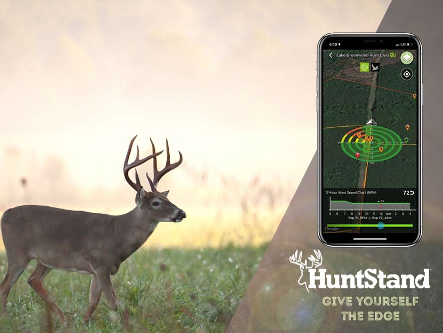
Wind and Weather
The HuntZone™ is a popular and useful feature of HuntStand™ . The concept is intriguing. It takes forecasted wind directions and speeds and displays how that wind should travel through a specified area factoring in hills, ridges and other terrain. It’s not fail-safe (nothing can replace paying attention to wind in the field) but I have found it to be a very good indicator of where my scent is blowing. The other weather features of the map are excellent as well. Rather than switching back and forth between apps, I’m able to get an accurate 5-day forecast that includes wind details. Plus, I can see hourly details for the next 72 hours. Toss in the solunar features which display moon phases and you have all the weather detail you could ever need.